Wolcottville
In a useless condition
Published .
Every few years an insurance surveyor came to Wolcottville and drew the town.
He drew every building on Main Street and lettered what each one sold. He marked which were brick and which were frame, where the stairs were, which walls were shared. He noted what the hotel used for heat and what it used for light. He was not writing a history. He was pricing the chance that any of it would burn, and he needed to know what was standing and what would help if it did.
The Sanborn Map Company did this in towns all over the country, and the sheets are the reason any of this is known.
The first edition is from May of 1895. The town had seven hundred people.
Under water facilities, the surveyor wrote a note rather than a number. The town drew from private wells and from the mill race. There were three-quarter inch pipes in Main Street, and those were used to sprinkle the street.
Then he wrote the sentence that tells you where the town actually stood.
The elevated tank from which water is to be drawn is in a useless condition.
Under engines he wrote no steam and no hand engines. Under hose carts, none.
So in 1895 a town of seven hundred people had a broken tank, some pipes for keeping the dust down, and nothing at all to put out a fire with.
By March of 1901 the population was nine hundred and there was one hand engine.
There were thirty volunteers and a hook and ladder truck, and five hundred feet of inch-and-a-half hose. Still no independent hose carts. Water still came from the wells and the race.
By June of 1907 there were a thousand people, and for the first time the map shows a building.
It stands on First Street, twenty-two feet across, one storey, frame. The surveyor lettered it ENG. HO., and beside it he listed what was inside:
One hand engine. One combination hose and ladder wagon. Five hundred fifty feet of two inch cotton hose, first class. Three hundred feet of the same, third class.
The cartouche adds the rest. A volunteer company, eighteen men, none of them paid. Two five gallon chemical extinguishers. The fire alarm was a bell on the engine house.
Two doors east, building 118 is lettered CALABOOSE, eight feet, iron clad.
Water facilities in 1907 still read as a note, and the note says private wells, cisterns, and the Little Elkhart River about five hundred feet north of Race Street.
Twelve years after the useless tank, the town's water was still the river.
The 1914 sheet has two brick buildings on Race Street that were not there before.
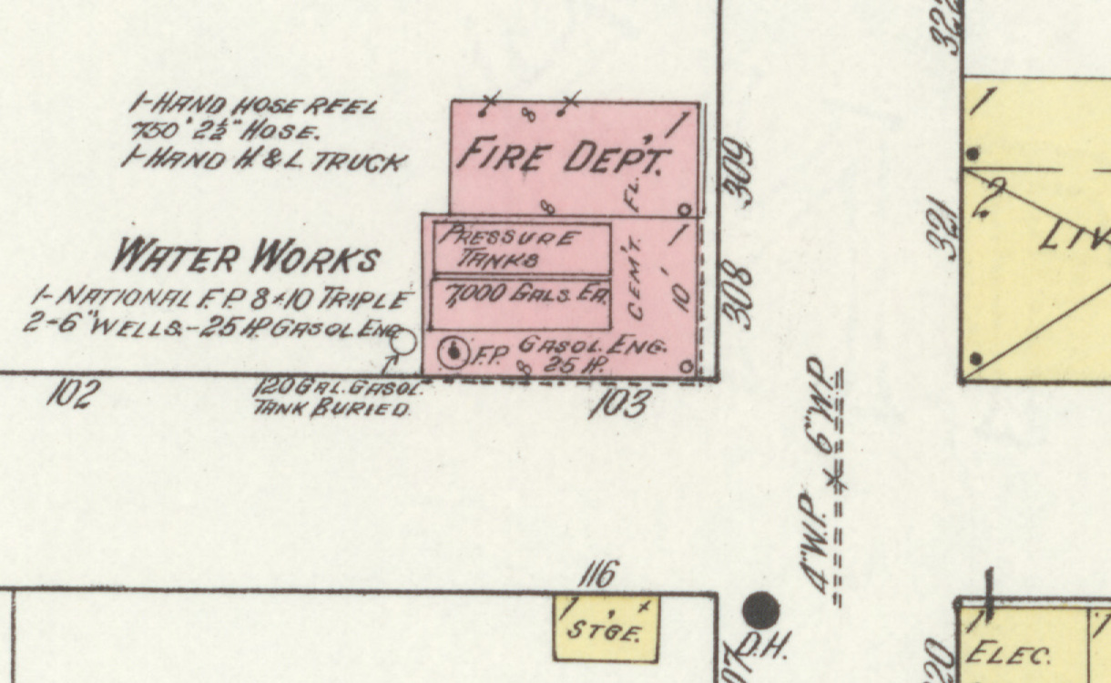
The first is lettered FIRE DEPT. Beside it: one hand hose reel, seven hundred fifty feet of two and a half inch hose, one hand hook and ladder truck.
The second has a cement floor and is lettered WATER WORKS.
Beside that one the surveyor wrote what was in it. One National fire pump, eight by ten, triple. Two six inch wells. A twenty-five horsepower gasoline engine. On the building itself he lettered pressure tanks, seven thousand gallons each. In the yard, a hundred twenty gallon gasoline tank, buried.
Four inch and six inch water pipe run along Race Street on the drawing, and there is a hydrant marked at the corner.
The 1922 sheet has the same two buildings with the same numbers, and both have more in them.
The fire department now holds a forty gallon chemical tank on a cart with a hundred feet of chemical hose, two hand hose reels with five hundred feet of hose apiece, and the hook and ladder truck.
The water works keeps everything it had, and gains one line.
One electrically driven four by five Hoosier pump, capacity twenty-three hundred gallons per hour.
Here is the part worth sitting with.
The cartouche never says the town got water. In 1895 it says see note, and the note says the tank is useless. In 1907 it says see note, and the note says the river. In 1914 it says see note. In 1922 it says see note.
If you read only the summary boxes, which is what they are there for, nothing changes across twenty-seven years.
The change is in the buildings. A frame engine house appears in 1907, and by 1914 there are two brick ones on Race Street with wells under them and pipe running down the road. Nobody wrote that the town solved its water problem. Somebody drew the buildings where it had been solved. The county seat had already done it, and its own sheets stopped calling the water not good after 1892.
Ford's county history, written in 1920, says Wolcottville installed a system of waterworks in 1908, with bonds issued against the town and two deep wells, one ninety feet down and the other a hundred ten. The Sanborn sheets do not confirm that date. They show no water works building in 1907 and two brick ones in 1914, with two six inch wells between them. The two accounts may describe the same system at different stages. The sheets do not say.
The rest of the sheets are the town going about its business while that happened.
In 1895 Main Street held a hotel, a druggist, dry goods, a milliner, a saloon, a meat market, a bakery, a hardware and agricultural implement dealer, a bank, and forty-four feet of vacant ground.
In 1907 three storefronts in a row are lettered "to be." To be a bank. To be a bakery and restaurant. To be dry goods. The surveyor came through while the block was going up and drew what he was told it would become.
The Commercial House is a hotel with stove heat and kerosene lamps in 1907, a hotel with steam heat in 1914, and by 1922 it is lettered rooming and boarding.
By 1914 the druggist has a six horsepower gasoline engine in the building, and it is still there in 1922.
The town had a thousand people in 1907 and a thousand people in 1922.
In between it got two brick buildings, five wells' worth of pipe, a pump that ran on electricity, and enough hose to reach most of Main Street.
Nobody put that in a county history. It is on an insurance map, in the margin, in the handwriting of a man who was there to work out what the town was worth if it burned.
Sources
- Sanborn Fire Insurance Map from Wolcottville, Noble and LaGrange Counties, Indiana. Five editions: May 1895, March 1901, June 1907, May 1914, April 1922, Sanborn Map Company, 1922. Library of Congress, Geography and Map Division. Carries every figure in this piece
- History of Northeast Indiana: LaGrange, Steuben, Noble and DeKalb Counties, volume 1, Ira Ford, 1920. Internet Archive. Cited for the 1908 waterworks date and the two deep wells, and for nothing else in this piece
The five Sanborn editions used here are one source series rather than five sources. They are the work of a single company returning to the same town, so agreement between them is one method repeated rather than corroboration. They are treated as documented because they are primary business records made on the ground for money, not a narrative written afterwards. Figures and lettering are transcribed from the sheets as drawn, including abbreviations. The 1920 history is quoted from a scanned original; obvious scanning errors have been corrected silently and no wording has been altered.
More from Wolcottville
Wolcottville
Wherever duty has called them
O. B. Taylor clerked in the store the town was named for, went to the Indiana House twice, and was credited with a drainage law nobody can name. Three years after the county printed his portrait he left for California.