Milford Township
The office the county history buried
Published .
The county's own history buried this place in a subordinate clause.
Battey's 1882 volume names Mount Pisgah exactly once. Not in the Milford Township chapter, which describes the township's business places, but four hundred pages away, at the end of a farmer's biography.
When the Mount Pisgah Post Office was in existence, Mr. Crowell served as Postmaster.
Was in existence. The office is recorded as a thing that had stopped.
The Post Office Department went on listing it for another twelve years.
Every few years the department printed a list of every post office in the country, arranged by state and county, with the postmaster's name beside it.
Mount Pisgah is in the Table of Post Offices for 1851, under La Grange County, between Marcy and Ontario. It is in the list for 1855, with its postmaster named: Fred. W. Austin. It is in the Official Postal Guide for 1870, for 1879, for 1889, and for 1894, where it appears twice, once in the main list and once in the Indiana county index, among the county's eighteen offices, beside Shipshewana, Topeka and Wolcottville.
It is not in the list for 1846, and it is gone from the guide for 1916.
So the office ran from somewhere before 1851 to somewhere after 1894, and for at least twelve of those years the county history had already written it off.
Which of them is wrong cannot be settled here. Either Battey's informant was mistaken, or the office lapsed in the 1880s and came back, and no list was found for the years between 1880 and 1888 to say which.
The maps kept it longer than the history did.
The state map of 1852 letters Mt Pisgah P.O. in italic. The county sheets of 1896 and 1904 letter it. The railway mail map of 1897 gives it a station dot on a route running north out of South Milford, with a little drawn mountain above the name, which is the mapmaker's joke about the word rather than a fact about the ground.
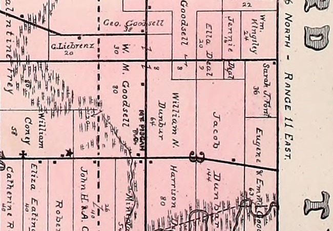
And the township plat of 1893 letters it where it stood: sideways along the road, MT. PISGAH with P.O. beneath, between W. M. Goodsell's eighty acres and William N. Dunbar's sixty-four, a mile south of the Springfield line, at the corner of sections three, four, nine and ten.
That year twenty-three farmers in the atlas gave it as their post office address.
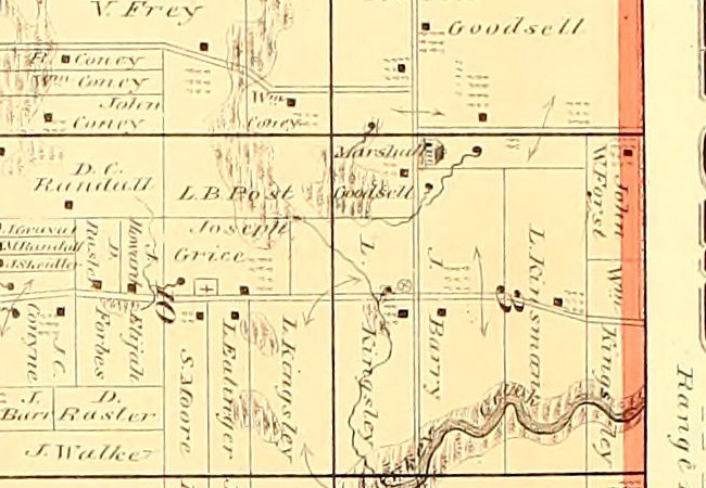
The 1874 atlas is the odd one. It draws the buildings at that corner, and a symbol at the road junction, and it letters Brushy Prairie P.O. and Mongo P.O. elsewhere on its sheets. It does not letter this name at all. That is the decade Battey was writing in.
What the place had, it kept without a plat. No map ever drew a street or a town lot there.
It had a store early. Ford's biographical volume records a partnership making potash and keeping stores "both at South Milford and Mt. Pisgah" in the 1840s, with Ed Wright in charge of the Mt. Pisgah branch, before Baxter left for Michigan in 1849.
It had a store late, and a cooperative one. The Mt. Pisgah Mercantile Association was a farmers' club that handled a general stock, and a man who had been its secretary told Ford's compiler it was the oldest association of its kind in the United States. By 1919 it was selling from Stroh, the cement town four miles south, whose own account already mentions the country post office that served that corner before rural delivery without ever naming it.
And it had the grove. From about 1892 the county's soldiers held their annual reunion there, and Ford, who did not think much of the place in his township chapter, called the gathering "the biggest affair in LaGrange County, aside from the annual 'Corn School.'"
Nobody in the record says who named it, or why. Post office names in this county did not always stay put: one of them moved house twice with its postmaster. This one kept its place and lost its record.
The name promises a mountain. What the nineteenth century record offers instead is a statement about the whole county. Leverett, surveying wells for the United States Geological Survey in 1899, wrote that LaGrange County
is one of the most elevated counties in the State, the greater part of its surface being above the 900-foot contour, while several tracts in the eastern part of the county, aggregating an area of perhaps 75 square miles, stand above the 1,000-foot contour.
He names no point in this county and measures none. He mentions no Pisgah. Battey, seventeen years earlier, put the southeast of the county "a little over 1,000 feet above the sea" against eight hundred in the northwest.
The ground is high. Nobody writing then said this spot was a hill.
Today the measurement can be taken. The United States Geological Survey's present-day elevation data, sampled in September 2026, puts the recorded site of Mount Pisgah at 972 feet, with a crest of about 1,047 feet half a mile to the northwest, against 928 feet at the county seat and 908 in the Pigeon River lowland.
That is a twenty-first century instrument answering a question the nineteenth century never asked here. The federal names database, for its part, records Mount Pisgah as a populated place rather than a summit. The only summit it holds in this county is called The Knob.
Ford had his chance to settle all of it. Opening his Milford Township chapter in 1920, he listed what the township had been:
Its hamlets and villages have been known as Mud Corners, South Milford, Mt. Pisgah, Elmira and Stroh, of which places see later.
He wrote about Stroh. He wrote about South Milford. He mentioned Mud Corners six times.
He never came back to Mt. Pisgah.
Three records would close what is still open. The Post Office Department's register of postmaster appointments, held by the National Archives, gives on one page the date an office was established, every postmaster in order, any discontinuance and re-establishment, and the day it closed for good. It would date this office exactly, place Crowell and Austin in it, and show whether the 1880s lapse the county history implies ever happened.
The Geological Survey's topographic sheets for this corner would show whether any federal map ever gave the spot a contour or a spot height.
And Charles Dryer's geology of LaGrange County, printed in the Indiana state survey's eighteenth annual report for 1893, is the one county-level study Leverett cites twice. It runs eleven pages. Nobody has opened it.
Sources
- Counties of LaGrange and Noble, Indiana: Historical and Biographical, F. A. Battey & Co., 1882. Internet Archive, countiesoflagran00infaba. The Milford Township biographies, for the single mention of the office, inside the sketch of Isaac Crowell. The Milford Township chapter itself does not name the place.
- History of Northeast Indiana: LaGrange, Steuben, Noble and DeKalb Counties, Ira Ford, 1920. Internet Archive, historyofnorthea11ford for the Milford Township chapter and the soldiers' reunion, and historyofnorthea02ford for the biographies that carry the store, the potash trade of the 1840s and the families who lived there.
- Illustrated Atlas and Columbian Souvenir of LaGrange County, Indiana, Durant, 1893. Internet Archive, historicalatlaslagr00dura. Leaf 43, printed page 39, the Milford Township plat, for the lettering. The list of resident freeholders, whose column head reads "SECTION AND POST OFFICE ADDRESS", for the twenty-three farmers who gave Mt. Pisgah as theirs.
- List of Post Offices in the United States, Post Office Department, 1855. Internet Archive, listpostoffices01deptgoog, scan leaf 91, read off the page image. The line gives the office, the county, the state abbreviated Ia. for Indiana, and the postmaster.
- United States Official Postal Guide, Post Office Department, 1894. Internet Archive, unitedstatesoff1894v1unit, the main list and the Indiana county index, both read here. The office also appears in the guides for 1870, 1879 and 1889, and in the Table of Post Offices for 1851. It is absent from the 1846 list and from the guide for 1916.
- Wells of Northern Indiana, Water-Supply Paper 21, Frank Leverett, United States Geological Survey, 1899. pubs.usgs.gov, printed page 25, read off the page image. For the county's contours. Leverett gives no point elevation for this county and does not name this place.
The county histories, the atlas and the postal lists are read as scanned text, and obvious scanning errors have been corrected silently with no wording changed. Every quotation here was then read off the page image, which matters in this case more than usual: the 1879 postal guide prints this office as "Pi^ah" in its scan, so a search of that volume finds nothing while the entry sits on the page. No absence in this piece rests on a search alone. The elevation figures given for today come from the United States Geological Survey's present-day elevation data, sampled in September 2026. They are not a nineteenth century measurement and nothing in the historical record measures this ground.
More from LaGrange County
LaGrange County
Ten miles north of the southern extreme
This county was signed away in two pieces seven years apart, at Chicago in 1821 and at St Joseph in 1828. The line between the two cessions runs east and west through the middle of the county, and neither county history mentions that it is there.