LaGrange County
The county's smallest century
Published .
Both of this county's histories were written while it was shrinking.
Battey's volume came out in 1882, two years after the county reached the largest it would be for the next seventy years. Ford's came out in 1920, when the county held four thousand fewer people than it had in 1880, and was still falling.
Neither book says so. The 1893 atlas printed a table headed Census by Townships, 1840-1890, and it ends on the highest figure in its own column. Ford reprinted that table in 1920 and added two decades to it. A reader of either book would put the county's best years in the 1880s and take the rest on faith.
This site repeated that reading until the eighteenth of September, 2026.The federal count tells it the other way round.
The county held 8,387 people in 1850 and 15,630 in 1880. Then it fell for fifty years: 15,615 in 1890, 15,284 in 1900, 15,148 in 1910, 14,009 in 1920, and 13,780 in 1930, which is the fewest people the county has held since the Civil War.
It has risen at every census since. 17,380 in 1960. 25,550 in 1980. 34,909 in 2000. In 2020 the census counted 40,446, which is more than two and a half times the figure the county histories close on.
The townships say it more sharply, because they say it eleven times.
Not one of the eleven townships peaked in the nineteenth century. Eight of them peaked in 2020, at the last census taken. Lima peaked in 2010, and Milford and Springfield in 2000, and those three are the only ones anywhere on this page that hold fewer people now than they once did.
Every one of the eleven now holds more people than it held before 1900. The narrowest case is Greenfield, which had 1,181 in 1880 and has 1,323, and the widest is Eden, which had 1,138 in 1890 and has 4,894.
The falls were real and they were long. Clay went from 1,408 in 1880 to 905 in 1920, and did not pass its 1880 figure again until 1970. Van Buren lost more than a third of its people between 1880 and 1920, from 1,376 to 871. Greenfield's fall ran sixty years, from 1,181 in 1880 to 732 in 1940, and it has never grown much since.
One number on this page used to be wrong, and the book that carried it says so itself.
The atlas's table gives the county 15,708 people in 1890. The census gives 15,615. The atlas column is not a slip: added up, it comes to its own printed total exactly. What it is can be read three lines further down the same page, where the atlas prints a second block of town populations, and the whole 1890 column of that block reads:
(Not yet published.)
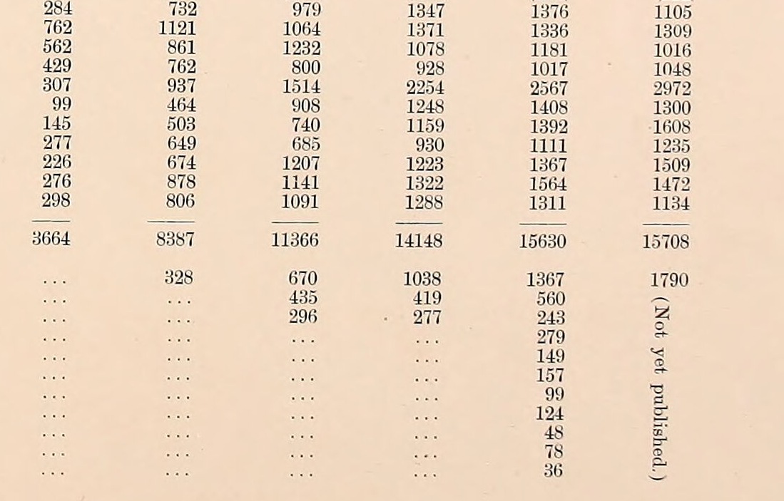
The atlas went to press before the Census Office had published the 1890 detail. Its township figures for that year are the best numbers available in 1893, not the count. Ford reprinted them in 1920 without saying so, and this site carried the figure on its timeline until it was corrected.
What the census cannot do is see the small places.
Mongo, Stroh and South Milford appear nowhere in any of these tables as places of their own, in any year from 1850 to 2020. They were never incorporated, or never large enough to be counted separately, so a hundred and seventy years of federal enumeration records them only inside the townships they sit in.
The county histories, for all they got wrong about the direction, are still the only books that name them.
Ford finished his chapters in 1920 with the county smaller than it had been when Battey wrote, and getting smaller. Ten years later it reached its lowest point. Nobody wrote a county history after that.
Sources
- Census of Population and Housing, Public Law 94-171 Redistricting Data, United States Census Bureau, 2020. The 2000, 2010 and 2020 counts here are parsed from the Bureau's own redistricting files for Indiana, which are born digital. No scanning and no character recognition stands between those figures and this page. The county total for 2020 was checked against a second federal file, the Bureau's population estimates, which gives a 2020 base of 40,453.
- Population of States and Counties of the United States: 1790 to 1990, United States Census Bureau, 1996. For the county row from 1850 to 1990, read off the page image of the Indiana tables. The township figures come from the published volume for each census in turn: the 1870 and 1880 compendia, the 1910 volume's Table 1, the 1920 bulletin, and the 1950, 1960, 1970, 1980 and 1990 volumes.
- Illustrated Atlas and Columbian Souvenir of LaGrange County, Indiana, Durant, 1893. Internet Archive, leaf 67, for the table headed Census by Townships, 1840-1890, and for the block of town populations beneath it whose 1890 column is printed "(Not yet published.)".
- History of Northeast Indiana: LaGrange, Steuben, Noble and DeKalb Counties, Ira Ford, 1920. Internet Archive, printed page 110, where the atlas's table is reprinted with 1900 and 1910 added, and the township chapters, which give each township's population for 1890, 1900 and 1910 in prose.
The figures on this page come from two kinds of evidence and the difference matters. The counts for 2000, 2010 and 2020 are born digital, taken from the Census Bureau's own data files. Everything from 1850 to 1990 was read off page images of the published volumes, and two cells were found damaged on the page and corrected by re-rendering them at high magnification rather than by inferring them from the arithmetic. Every township column here sums exactly to its printed county total, which is the test that decided what could be published. One column failed that test and is not on this page: the eleven townships in 1930 sum to nine people short of the printed county figure, so the county's 1930 total is given and its townships are not. The townships for 1850 and 1860 are absent for a different reason, which is that nobody has yet looked for those tables.
Correction
This piece ran the 1893 atlas table on its side. The crop was rotated a quarter turn during preparation, so every column of figures lay sideways, and the credit said the plate had been turned upright when it had not. The image is now the same crop as the atlas prints it, with the columns upright and the bracketed note set vertically in the last column, which is how the book sets it. The credit now says what was done to the file. No figure, and nothing in the argument, changed.
More from LaGrange County
LaGrange County
Ten miles north of the southern extreme
This county was signed away in two pieces seven years apart, at Chicago in 1821 and at St Joseph in 1828. The line between the two cessions runs east and west through the middle of the county, and neither county history mentions that it is there.