The county in order
From the first cabin west of Lima to the year both of the county's chronologies stop. Forty one of the things that changed what this county was, in the order they happened, with the pieces hung off them.
It is not a chronology. The county has two of those already, printed in 1893 and 1920, and neither is readable straight through. This is a selection, and what has been left out is most of them: the church dedications, the store fires, the roller skating craze.
1828
Benjamin Blair and his family make the first settlement in the county, half a mile west of Lima, then called Mongoquinong, or Big Squaw Village.
Lima Township · 1893 atlas chronology; Ford
1829
Moses and Ica Rice settle, the latter opening a trading house.
1893 atlas chronology
1831
The first church in the county, Methodist, is organised near Lima at Robert Hamilton's house. The first grist mill is built at Mongo, then called Union Mills.
1893 atlas chronology
1832
The county is separated from Elkhart and organised. The first term of court is held at the house of Moses Rice on 22 October, and the county seat is located at Lima.
1893 atlas chronology; Battey
1832
A rumour of hostilities empties the settlements. Families flee to Lexington and fortify a place they call Fort Donaldson, against a massacre that had not happened.
Greenfield Township · Battey; 1893 atlas chronology
1833
The first log schoolhouse is built near Lima, and the first courthouse with it.
Lima Township · 1893 atlas chronology
1834
Springfield Township is constituted. James B. Howe is admitted to the bar as the county's first resident attorney.
1893 atlas chronology; Ford
1835
Lexington is platted, and the Buffalo and Mississippi railroad is surveyed through the county. It was never built.
1893 atlas chronology
1836
LaGrange is platted on 18 June by Reuben J. Dawson, William F. Beavers, George F. Whittaker and James McConnell.
Ford, the plat record; 1893 atlas chronology
1836
Vistula is platted on the shore of Wall Lake, in what is now Greenfield Township. Ford calls it a paper town. Men in the East bought corner lots in a village that did not exist.
Greenfield Township · Ford, the plat record; Battey
1836
Nathan Jenks founds the LaGrange Collegiate Institute, one of the first institutions of higher education in northern Indiana.
Battey; 1893 atlas chronology
1837
Ontario is platted by Nathan Jenks on 1 March. Newbury, Clearspring, Johnson and Milford townships are constituted.
1893 atlas chronology; Ford, the plat record
1837
The 1893 atlas gives this year one clause: Pottawotamie Indians removed from the county. Ford's chronology gives it one clause and nothing else at all: Pottawattomie Indians removed from the territory. The two records differ by a word, county against territory, and neither says who, or how, or where to. The 1882 history has no entry for it.
1893 atlas chronology; Ford
1838
The county votes stock to the Buffalo and Mississippi railroad. The autumn is marked by extreme drought and unusual sickness, and settlers suffer badly from malarial fevers.
1893 atlas chronology; Battey
1840 census: the county holds 3,664 people
1842
Samuel Hemenway establishes the county's first newspaper at Ontario.
1893 atlas chronology
1844
The county offices are removed from Lima to LaGrange. C. B. Holmes is appointed the first postmaster there.
1893 atlas chronology; Ford
1844
The first Amish settlement in Newbury Township. Three books carry the date and one of them is copying another.
Newbury Township · Battey; 1893 atlas chronology; Ford
1844
The LaGrange Phalanx, a Fourier organisation, is formed in Springfield Township. A hundred and twenty people from Indiana and Michigan lived under one roof and ate at the same table.
Springfield Township · Battey; 1893 atlas chronology
1846
The first teachers' institute in Indiana is held at Ontario by Rufus Patch.
1893 atlas chronology; Ford
1848
The LaGrange Phalanx dissolves, four years after it was chartered.
Springfield Township · 1893 atlas chronology
1850
People escaping slavery move north through a station in Milford Township. The house was known to colored people far down in the Southern States.
Milford Township · Battey; 1893 atlas chronology
1850 census: the county holds 8,387 people
1852
The state legislature authorises companies in LaGrange and the counties around it to break up bands of thieves and counterfeiters.
1893 atlas chronology; Ford
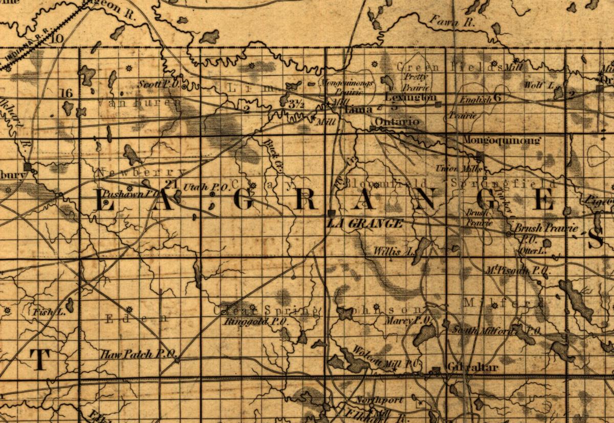
Map of the state of Indiana compiled from the United States surveys by S. D. King, Washington City, New York, 1852, via the Library of Congress. The county before any railroad reached it. 1854
Ground is broken for the Grand Rapids and Indiana railroad, sixteen years before a train reached the county.
1893 atlas chronology
1857
The LaGrange Standard is established by John K. Morrow, the county's first Republican paper.
Bloomfield Township · 1893 atlas chronology; Battey
1858
Gregory McDougal is hanged by regulators near Diamond Lake in Noble County on 26 January.
1893 atlas chronology
1860 census: the county holds 11,366 people
1861
The first call for volunteers. The LaGrange Tigers leave for Indianapolis on 21 May under William Roy, and become Company A of the Twenty-first Regiment.
1893 atlas chronology; Battey
1862
The militia return for the county comes back with a line in it: conscientiously opposed to bearing arms, 91. Eleven thousand words on this county's war never use the word Amish.
Battey
1864
LaGrange County is asked for 191 men on the President's call for three hundred thousand more.
1893 atlas chronology
1865
The county commissioners offer a bounty of four hundred dollars to each volunteer and issue bonds for the money.
1893 atlas chronology
1870
The first locomotive reaches LaGrange from Sturgis on 11 April, to a cannon and a band. The county had sent its men to the war on foot.
Bloomfield Township · Battey; 1893 atlas chronology
1870 census: the county holds 14,148 people
1873
The county votes on ninety eight thousand dollars for the New York and Chicago Air Line, a railway east and west through the middle of the county. It is defeated, 1,520 against and 1,220 for.
Battey; 1893 atlas chronology
1874
The name of Mongoquinong is changed to Mongo.
Springfield Township · 1893 atlas chronology
1874
The First National Bank of LaGrange is organised on 1 August.
Bloomfield Township · 1893 atlas chronology

Map of La Grange County, Indiana, compiled and drawn by S. W. Durant, August 1874, from the Illustrated Historical Atlas of LaGrange County, Andreas and Baskin, Chicago. Leaf 16, printed page 12, via the Internet Archive. 1876
A steam boiler explodes at a mill near LaGrange. Joseph Kennedy, Sebastian Gross and Henry Corwin are killed instantly.
Bloomfield Township · 1893 atlas chronology
1878
The cornerstone of the new courthouse is laid on 15 August. A copper box goes into the cavity and Samuel P. Bradford reads out what is in it.
Bloomfield Township · Battey; 1893 atlas chronology
1879
The county offices move into the new courthouse in November. It was paid for in cash.
Bloomfield Township · 1893 atlas chronology
1880 census: the county holds 15,630 people
1883
The only tornado in the county's history passes through Van Buren Township on 14 May, destroying several buildings and killing William Moak. Damage is put at a hundred thousand dollars.
Van Buren Township · 1893 atlas chronology
Detail from Cram's township and rail road map of Indiana, George F. Cram, Chicago, 1888, via the Library of Congress. Eighteen years after the first locomotive, still one line. 1889
Shipshewana is platted on 18 January, in section 12, township 37, range 8, by Hezekiah Davis and Sarah R. Davis.
Newbury Township · Ford, the plat record
1890 census: the county holds 15,615 people
1891
Grading begins on the Wabash railroad extension. Both of the county's chronologies stop here.
1893 atlas chronology
1893
The Wabash is completed through the southern tier of townships, with stations at Topeka, Eddy and South Milford, and at Wolcottville just over the Noble County line. The county had waited fifty seven years since the first railroad was surveyed through it.
Ford, the railroads chapter

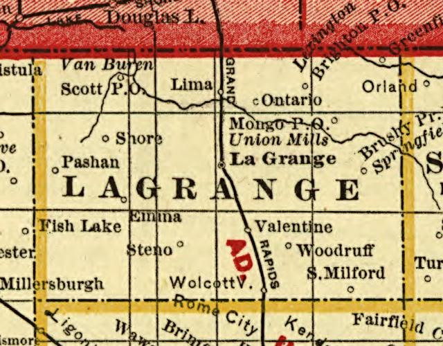
Map of La Grange County, Indiana, from the Illustrated Atlas and Columbian Souvenir of LaGrange County, LaGrange Publishing Company, 1893. Leaf 21, via the Internet Archive. Rotated ninety degrees counter clockwise, see the note on this page.
Why it stops here
Both of this county's chronologies end in 1891. The 1893 atlas printed one, and when Ira Ford came through in 1920 he reprinted it, shorter and lightly reworded, and added nothing after the year it stopped. So 1891 is where the county's record of itself runs out, rather than where its history does.
What the archive holds for the twenty eight years after it is thin and it is worth naming rather than padding. Stroh was platted as Hayward in 1899. The Wabash came through the southern tier about 1893 and the St Joseph Valley line about 1900. LaGrange got waterworks in 1908. Lima changed its name to Howe in 1909. Dr. John H. Rerick, who wrote eight chapters of the 1882 history and owned the county's newspaper, died in January of 1911. Thirty five people put their names to a bank at Stroh in 1915, seven of them women. Shipshewana incorporated as a village in April of 1916.
The census is the only source that carries past 1891, and it carries a turn. The county held 15,615 people in 1890 and fell for forty years after it. It has risen at every census since, and now holds more than twice what it held when these chronologies stop. That series, and the eleven townships beneath it, are in the county's smallest century.
The two county histories were published in 1882 and 1920. After that nobody wrote one.
The 1893 county map is printed sideways in the atlas, a landscape sheet bound into a portrait book, and the copy on this page has been rotated ninety degrees counter clockwise so it reads the right way up. Nothing else was done to it: no crop inside the border, no scaling beyond the web size, no clean up. The as scanned original is held unrotated in the research directory. A rotation is a correction to how a sheet was photographed rather than a change to what it records, which is why it is allowed and why it is not done silently.
On 18 September 2026 this page's closing note was corrected. It had said that the county's population in 1890 was 15,708 and the most it ever held, and that nine of the eleven townships had already peaked. All three were wrong, and the last was backwards. The 1890 figure came from the 1893 atlas, whose own table of town populations for that year is printed Not yet published, so its township figures were set before the Census Office published the detail. The published federal count is 15,615. The census of 2020 counted 40,446 people in this county, and the Census Bureau's own population estimates give a 2020 base of 40,453, so the county now holds more than twice what it held in 1890. No township peaked in the nineteenth century: eight peaked in 2020, one in 2010 and two in 2000. The same day this note was shortened to point at that piece, which now carries the full series, the eleven townships and the sources behind them.
On 15 September 2026 the 1893 entry was changed to say the Wabash's Wolcottville station stood in Noble County, not LaGrange. The evidence is in the correction on the railroads piece.
Where two books carry the same event the earlier one is named first. Ford's chronology is a reworking of the 1893 atlas's rather than an independent account of the county, so an event in both books is one witness and not two.